Captain James Cook: Charting the Unknown

Loading story...

A young boy looking out over the Yorkshire moors toward the distant sea
1728 Yorkshire, England

A Farm Boy's Horizon

James Cook was born on October 27, 1728, in the small village of Marton in Yorkshire, England, the son of a Scottish farm laborer. He spent his early years working the land, but the sea called to him with an irresistible pull. At seventeen, he apprenticed with a coal-shipping company in Whitby, learning seamanship aboard the rugged collier vessels that worked the North Sea. These unglamorous ships gave Cook an education in practical navigation that no naval academy could match—and would later inspire his choice of sturdy, flat-bottomed vessels for his voyages of discovery.
British naval ships navigating the treacherous St. Lawrence River
1759 St. Lawrence River, Canada

Charting the St. Lawrence

Cook joined the Royal Navy in 1755 and quickly distinguished himself as a master surveyor during the Seven Years' War. In 1759, General Wolfe's campaign to capture Quebec depended on safely navigating the treacherous St. Lawrence River, and Cook was chosen to chart it. Working at night under enemy fire, he produced charts so accurate that they guided the British fleet safely to Quebec, enabling the decisive siege. His feat did not go unnoticed—the Admiralty recognized that this self-taught son of a farmhand possessed a rare and extraordinary talent.
HMS Endeavour sailing through Polynesian waters under full sail
1768–1771 Pacific Ocean

The First Voyage: Venus and the South Seas

In 1768, the Royal Society and the Admiralty commissioned Cook to sail to Tahiti to observe the Transit of Venus across the sun—a rare astronomical event that would help calculate the distance from the Earth to the sun. Aboard the converted collier HMS Endeavour, Cook carried a crew of ninety-four, including the botanist Joseph Banks and his team of naturalists. After successfully recording the transit from Tahiti in June 1769, Cook opened his secret sealed orders and sailed south and west, becoming the first European to circumnavigate and chart New Zealand's coastline in its entirety. The voyage proved conclusively that New Zealand was two separate islands, not the edge of a vast southern continent.
HMS Endeavour sailing along a dramatic coastline of golden cliffs and eucalyptus forest
1770 Eastern Australia

Australia: The Eastern Shore

In April 1770, HMS Endeavour made landfall on the southeastern coast of Australia—a continent already known to Dutch navigators from its western and northern shores, but whose eastern coast remained a blank on European maps. Cook sailed north along the coast for four months, meticulously charting what he named New South Wales. In August, he formally claimed the territory for the British Crown at Possession Island near Cape York. The voyage brought back thousands of previously unknown plant and animal specimens collected by Banks, astonishing European scientists and forever changing the world's understanding of natural history.
A ship pushing through pack ice near the Antarctic Circle under a pale polar sky
1772–1775 Southern Ocean

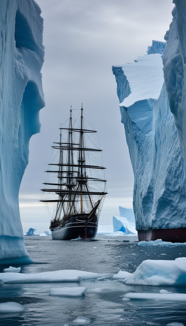
The Second Voyage: The Southern Ice

Spurred by persistent theories that a vast habitable continent called Terra Australis lay somewhere in the far south, the Admiralty sent Cook on a second voyage in 1772 with two ships, Resolution and Adventure. He became the first person in recorded history to cross the Antarctic Circle, on January 17, 1773, pushing south into waters choked with ice and fog. Three times he crossed the Circle, coming within 75 miles of the Antarctic continent, before pack ice turned him back each time. Though he never saw Antarctica itself, he concluded definitively that any land at the South Pole was frozen, desolate, and of no commercial value—effectively ending two centuries of speculation about a temperate southern paradise.
Sailors eating fresh citrus and sauerkraut on deck, with a healthy crew at work
1769–1775 At Sea

Defeating the Silent Killer

Scurvy—caused by vitamin C deficiency—was the most feared killer in the Age of Sail, routinely decimating crews on long voyages. Cook was determined to defeat it through strict discipline over diet. He insisted his men eat fresh citrus, sauerkraut, and portable soup at every port, even flogging those who refused. On his second voyage, not a single man died of scurvy—an almost miraculous achievement for an era when the disease could kill half a crew. The Royal Society awarded Cook its highest honor, the Copley Medal, in 1776 largely for this accomplishment, which saved countless sailors' lives in the decades that followed.
A ship navigating through fog and Arctic ice in search of the Northwest Passage
1776–1779 Arctic Ocean

The Third Voyage: The Northwest Passage

Cook's third and final voyage, begun in 1776, sent him north toward the Arctic in search of the legendary Northwest Passage—a hoped-for sea route connecting the Atlantic and Pacific over the top of North America. He sailed up the North American coast through the Bering Strait and into the Arctic Ocean, reaching latitude 70° 44' North before impenetrable pack ice turned him back. Along the way he charted the Hawaiian Islands—which he named the Sandwich Islands—with stunning accuracy, and surveyed vast stretches of the Alaskan and Northwest Pacific coasts that had never appeared on a European map. Cook had now charted more of the earth's surface than any explorer in history.
A confrontation on a Hawaiian beach at dawn, with canoes and warriors in the surf
February 14, 1779 Kealakekua Bay, Hawaii

Death at Kealakekua Bay

In February 1779, Cook returned to Kealakekua Bay on the Big Island of Hawaii after storm damage forced his ships back from the Arctic. Tensions with the native Hawaiians, initially friendly, had grown strained during his first visit. When a small cutter was stolen from one of his ships, Cook went ashore on February 14 with a marine escort to take the local chief hostage as ransom. The confrontation on the beach escalated rapidly when news arrived that Hawaiians had killed a British sailor in a separate incident. Cook was surrounded, struck from behind, and stabbed to death in the surf. He was fifty years old. The greatest navigator of the age died not at sea, but in the shallows of a Pacific beach, far from Yorkshire.
A sweeping view of the Pacific Ocean at golden hour, with a tall ship silhouetted on the horizon

The Man Who Mapped the World

In three extraordinary voyages spanning barely a decade, James Cook charted more of the earth's surface than any explorer before him. He circumnavigated New Zealand, mapped the east coast of Australia, crossed the Antarctic Circle, surveyed the Hawaiian Islands, and probed the Arctic ice in search of the Northwest Passage. He demonstrated that a ship's crew could survive a voyage of three years without losing a man to scurvy. The farm boy from Yorkshire who taught himself to navigate by the stars left behind charts so accurate that they were still in use well into the twentieth century—a monument to curiosity, discipline, and the relentless human desire to know what lies beyond the horizon.

Recommended Reading

As an Amazon Associate, we earn from qualifying purchases.

Swipe to navigate